Enregistrez gratuitement cette image
en 800 pixels pour usage maquette
(click droit, Enregistrer l'image sous...)
|
|
Réf : T02362
Thème :
Terre vue de l'espace - Plaines - Plateaux - Vallées - Général (487 images)
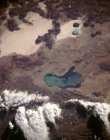
Titre : Altiplano, Southwest Bolivia October 1985
Description : (La description de cette image n'existe qu'en anglais)
Part of the high plateau known as the Altiplano in southwestern Bolivia, with average elevations exceeding 12 000 feet (3660 meters), is captured in this near-vertical photograph. The Altiplano is a sediment-filled depression that is bounded by the volcanic peaks of the Cordillera Occidental to the west and the folded mountain ranges of the Cordillera Oriental to the east. Numerous volcanoes, some with peaks exceeding 16 000 feet (4875 meters), are visible along the western edge of the photograph. The two large, highly reflective features are dry lake beds (salars) where salt has been deposited on the ground. The smaller, northernmost salt marsh is the Salar de Coipasa, and the larger, highly reflective surface is the Salar de Uyuni. Lake Poopó, the shallow lake whose depth never exceeds 15 feet (4.5 meters), displays a sediment plume dispersed throughout the lake. Although Lake Poopó receives some water from drainage along its southern end, the major water supply flows into the northern end of the lake via the intermittently flowing Desaguadero River, which connects Lake Titicaca with Lake Poopó.
|
|

